题目内容
3. Mapping Antarctica
Antarctica was on the map long before anyone ever laid eyes on it.Nearly 2,400years ago,ancient Greek philosophers such as Aristotle believed that a great continent must exist at the bottom of the world.They thought it was needed to balance out the continents at the top of the world.In the 1500s,mapmakers often included a fanciful continent they referred to as Terra Incognita (Latin for"unknown land") at the bottom of their maps.But it was not until the 1800s----after explorers had sighted and set foot on Antarctica----that mapmakers got down to the business of really mapping the continent,which is one-and-a-half times the size of the U.S..
While the coastline could be mapped by ships sailing around the continent,it took airplanes----and later,satellites----to chart Antarctica's vast interior (内陆).That job continues today.And it is a job that can still require a mapmaker,or cartographer,to put on boots and head out into the wild.
Cole Kelleher is familiar with that.He is a cartographer with the Polar Geospatial Center (PGC),which is based at the University of Minnesota and has a staff at McMurdo Station.PGC teamed up with Google to use the company's Trekker technology to capture images of Antarctica for the Internet giant's popular feature,Street View.A Trekker camera,which is the size of a basketball,is set about two feet above a backpack.The camera records images in all directions."It weighs about 50pounds.I was out for two and a half days,hiking 10to 12hours each day,"says Kelleher.It was hard work,but really an incredible experience."According to Kelleher there are plans to use the technology to create educational apps for museums.

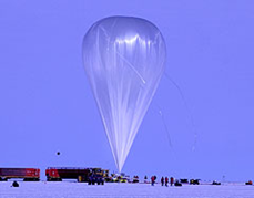
The PGC staff at McMurdo Station provides highly specialized mapmaking services for the U.S.Antarctic Program.For one project,Kelleher used satellite images to map huge cracks in the ice.That helped a team of researchers know whether they could safely approach their field camp on snowmobiles.Another recent project was to help recover a giant,high-tech helium (氦气) balloon used to carry scientific instruments high into the atmosphere.These balloons are launched in Antarctica because there is no danger that they will hurt anyone when they fall back down to Earth.Using satellite images,Kelleher and colleagues created maps of where the balloon could be found.
Antarctica may no longer be Terra Incognita,but it still holds countless mysteries.Cartographers and the maps they make will continue to be essential in helping scientists unlock those secrets.
74.From the passage,we can infer that Antarctic was on the map in the 1500s whenC.
A.mapmakers knew it was much larger than the U.S.
B.Aristotle named the continent Terra Incognita
C.no one had ever seen or been to the continent
D.it was such an interesting continent as was often referred to
75.Which of the following statements is NOT true according to the passage?B
A.It needs much work for the mapmakers to head out into the wild.
B.The interior can only be mapped by planes and satellites.
C.It is relatively easy to map Antarctica's coastline by ships.
D.Antarctic is a vast but still mysterious continent.
76.The Polar Geospatial Center (PGC) works with Google initiallyA.
A.to capture images of Antarctica for Street View
B.to test the company's Trekker technology
C.to create educational apps for museums
D.to hike for an incredible experience
77.The fourth paragraph mainly talks aboutD.
A.satellite images which are used to map huge cracks in the ice
B.a high-tech helium balloon for carrying scientific instruments
C.how to safely approach the researchers'field camp and the balloon
D.the specialized mapmaking services provided by the PGC staff.
分析 本文属于说明文阅读,作者通过这篇文章主要向我们描述了映射的南极洲,南极洲在16世纪之前都是一个幻想大陆,19世纪被发现后其海岸线可以通过船只飞机和卫星映射出来,PGC还在有计划地绘制南极洲的地图,探索它的奥秘.
解答 74.C.推理判断题.根据文章第一段"In the 1500s,mapmakers often included a fanciful continent they referred to as Terra Incognita (Latin for"unknown land") at the bottom of their maps"在16世纪,制图者通常包括一个幻想大陆被他们称为Terra Incognita(拉丁语为"未知的土地")在地图的底部,可知,没有人见过或者去过南极;故选C.
75.B.细节理解题.根据文章第二段"While the coastline could be mapped by ships sailing around the continent,it took airplanes----and later,satellites----to chart Antarctica's vast interior (内陆)."可知内陆可以由轮船,飞机和卫星映射;故B选项错误;故选B.
76.A.细节理解题.根据文章第三段"PGC teamed up with Google to use the company's Trekker technology to capture images of Antarctica for the Internet giant's popular feature,Street View"极地地理信息中心(PGC)与谷歌首次合作拍摄南极洲街景;故选A.
77.D.主旨大意题.根据文章第四段"The PGC staff at McMurdo Station provides highly specialized mapmaking services for the U.S."可知主要讲麦克默多站的PGC员工提供高度专业化的制图服务为美国;故选D,
点评 考察学生的细节理解和推理判断能力,做细节理解题时一定要找到文章中的原句,和题干进行比较,再做出正确的选择.在做推理判断题不要以个人的主观想象代替文章的事实,要根据文章事实进行合乎逻辑的推理判断.

| A. | had the limousine arrived | B. | did the limousine arrive | ||
| C. | had the limousine arrive | D. | arrived the limousine |
| A. | careful | B. | common | C. | instant | D. | general |
| A. | make out | B. | turn out | C. | come out | D. | go out |
| A. | effective | B. | attractive | C. | impressive | D. | conservative |